


🗾 Introduction to the Ultimate List of Islands in New Zealand
New Zealand, a land of enchanting landscapes and rich cultural tapestry, is adorned not only by its mainland but also by many captivating islands, unfolding a unique chapter in the story of Aotearoa.
Join us on a virtual expedition as we explore the remarkable islands of New Zealand!
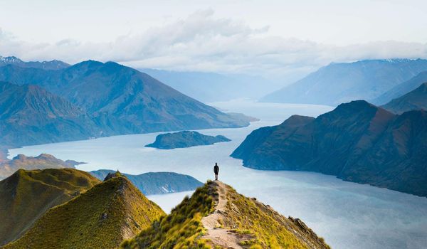
1. South Island (Te Waipounamu)
- Indigenous Name: Te Waipounamu.
- Area: Approximately 150,437 km².
- Area (sq mi): 58,084 sq mi.
- % of NZ Area: Covers 56.2% of New Zealand’s total land area.
- Population: 1,225,000 residents.
📍 Insights:
- Dominated by the Southern Alps.
- Home to iconic fjords, including Milford Sound and Doubtful Sound.
- Rich Māori heritage, with greenstone (Pounamu) having cultural importance.
- Popular for adventure activities in places like Queenstown.
- UNESCO World Heritage sites: Fiordland National Park, Aoraki/Mount Cook National Park.
- Varied landscapes, from golden tussock grasslands to snow-capped peaks.
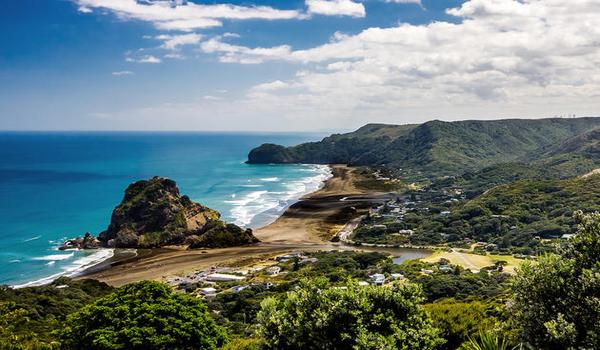
2. North Island (Te Ika-a-Māui)
- Indigenous Name: Te Ika-a-Māui.
- Area: Approximately 113,729 km².
- Area (sq mi): 43,911 sq mi.
- % of NZ Area: Represents 42.3% of New Zealand’s total land area.
- Population: 3,997,300 residents.
📍 Insights:
- Home to New Zealand’s capital, Wellington.
- Rich in cultural and historical significance.
- Geothermal wonders in Rotorua and the Bay of Plenty.
- Key urban centers include Auckland and Hamilton.
- Diverse landscapes, from volcanic regions to fertile plains.
- Cultural hub with a blend of Māori traditions and modern lifestyle.
3. Stewart Island / Rakiura
- Indigenous Name: Te Punga o Te Waka-a-Māui.
- Area: Approximately 1,683 km².
- Area (sq mi): 650 sq mi.
- % of NZ Area: Represents 0.6% of New Zealand’s total land area.
- Population: Around 400 residents.

📍 Insights:
- Located off the southern coast of the South Island.
- Enchanting landscapes with native forests and secluded beaches.
- Home to the Rakiura Track, offering a glimpse of pristine wilderness.
- Sparsely populated, providing a peaceful retreat.
- Te Punga o Te Waka-a-Māui translates to “The Anchor Stone of Māui’s Canoe.”
- A destination for nature enthusiasts seeking tranquility.
4. Chatham Island
- Indigenous Names: Rekohu (Moriori); Wharekauri (Māori).
- Area: Approximately 900 km².
- Area (sq mi): 350 sq mi.
- % of NZ Area: Represents 0.3% of New Zealand’s total land area.
- Population: Around 600 residents.
📍 Insights:
- Situated 800 km east of the South Island.
- Blends Moriori and Māori cultures, offering a unique cultural experience.
- Known for its distinct flora and fauna.
- Remote and secluded, providing an off-the-beaten-path destination.
- Wharekauri is the Māori name, and Rekohu reflects Moriori heritage.
- Unique ecosystems and biodiversity contribute to its appeal.
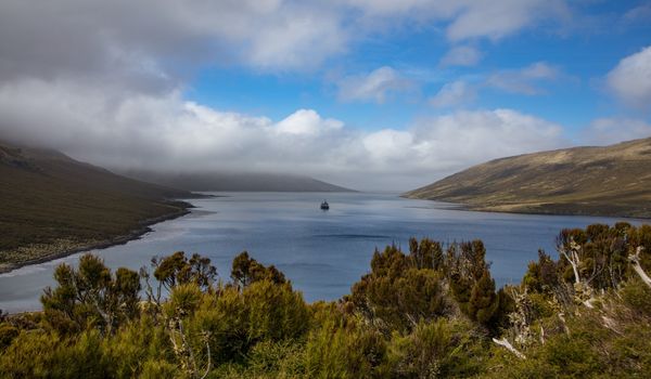
5. Auckland Island
- Indigenous Name: Mauka Huka.
- Area: Approximately 510 km².
- Area (sq mi): 200 sq mi.
- % of NZ Area: Represents 0.2% of New Zealand’s total land area.
- Population: Uninhabited.
📍 Insights:
- Part of the subantarctic islands, south of the South Island.
- Known for its rugged and remote subantarctic environment.
- Diverse wildlife, including seals, sea lions, and unique bird species.
- UNESCO World Heritage site, contributing to New Zealand’s biodiversity.
- Mauka Huka reflects the island’s native name in the Māori language.
- Signifies nature’s resilience and untouched beauty.
6. Great Barrier Island (Aotea Island)
- Indigenous Name: Not specified.
- Area: Approximately 285 km².
- Area (sq mi): 110 sq mi.
- % of NZ Area: Represents 0.1% of New Zealand’s total land area.
- Population: Around 850 residents.

📍 Insights:
- Located in the Hauraki Gulf, northeast of Auckland.
- Known for its natural beauty, beaches, and walking tracks.
- Aotea Island reflects its Māori name, signifying a place of white clouds.
- Home to diverse flora and fauna, including native bird species.
- Popular for eco-tourism and outdoor activities.
- Balances a small population with significant natural appeal.
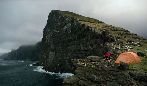
7. Resolution Island
- Indigenous Names: Mauīkatau, Tau Moana.
- Area: Approximately 208.87 km².
- Area (sq mi): 80.65 sq mi.
- % of NZ Area: Represents 0.1% of New Zealand’s total land area.
- Population: Uninhabited.

📍 Insights:
- Located in Fiordland, southwestern South Island.
- Mauīkatau and Tau Moana are the Māori names for the island.
- Serves as a sanctuary for native wildlife and conservation efforts.
- Part of New Zealand’s commitment to preserving coastal ecosystems.
- Accessible only by boat, contributing to its untouched beauty.
- A vital component of Fiordland’s ecological tapestry.
8. Rangitoto ki te Tonga / D’Urville Island
- Indigenous Names: Not specified.
- Area: Approximately 150 km².
- Area (sq mi): 58 sq mi.
- % of NZ Area: Represents less than 0.1% of New Zealand’s total land area.
- Population: About 52 residents.

📍 Insights:
- Situated in the Marlborough Sounds, northern South Island.
- Characterized by stunning coastal landscapes and native forests.
- Limited population, emphasizing its natural serenity.
- Offers walking tracks and opportunities for wildlife observation.
- Part of the Marlborough Sounds Conservation Area.
- An island getaway with a focus on preserving natural ecosystems.
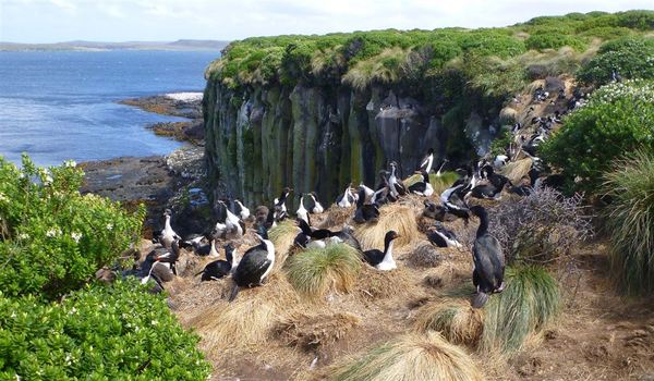
9. Campbell Island / Motu Ihupuku
- Indigenous Names: Not specified.
- Area: Approximately 112.68 km².
- Area (sq mi): 43.51 sq mi.
- % of NZ Area: Represents less than 0.1% of New Zealand’s total land area.
- Population: Uninhabited.
📍 Insights:
- Part of the subantarctic Auckland Islands group.
- Remote and isolated, located about 700 km south of the South Island.
- Unique ecosystem with diverse wildlife, including albatross colonies.
- Designated as a UNESCO World Heritage site for its ecological significance.
- Strict access regulations to preserve its natural state.
- Offers opportunities for scientific research and environmental studies.
10. Adams Island
- Indigenous Names: Not specified.
- Area: Approximately 100 km².
- Area (sq mi): 39 sq mi.
- % of NZ Area: Represents less than 0.1% of New Zealand’s total land area.
- Population: Uninhabited.
📍 Insights:
- Part of the subantarctic Auckland Islands group.
- Located south of the South Island, along with other subantarctic islands.
- Rich in biodiversity with unique plant and animal species.
- Protected nature reserve with limited human access.
- Forms part of New Zealand’s commitment to environmental conservation.
- Maintains a pristine and untouched natural environment.
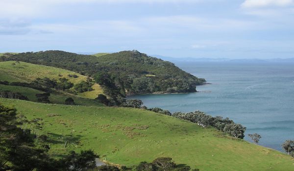
11. Waiheke Island
- Indigenous Names: Not specified.
- Area: Approximately 92 km².
- Area (sq mi): 36 sq mi.
- % of NZ Area: Represents less than 0.1% of New Zealand’s total land area.
- Population: Around 9,420 residents.

📍 Insights:
- Located in the Hauraki Gulf, close to Auckland.
- Known for its picturesque landscapes and vineyards.
- Popular as a residential and tourist destination.
- Offers a mix of outdoor activities and cultural experiences.
- Accessible by ferry from Auckland, contributing to its popularity.
- Blends natural beauty with a vibrant local community.
12. Secretary Island
- Indigenous Name: Kā Tū-waewae-o-Tū.
- Area: Approximately 81.4 km².
- Area (sq mi): 31.4 sq mi.
- % of NZ Area: Represents less than 0.1% of New Zealand’s total land area.
- Population: Uninhabited.

📍 Insights:
- Located in Fiordland, southwestern South Island.
- Kā Tū-waewae-o-Tū is the Māori name, signifying its cultural significance.
- Part of conservation efforts, serving as a sanctuary for native flora and fauna.
- Known for its pristine landscapes, coastal features, and native forests.
- Limited human impact, maintaining its ecological integrity.
- Accessible by boat, providing a glimpse into New Zealand’s untouched beauty.
13. Arapaoa Island
- Indigenous Names: Not specified.
- Area: Approximately 75 km².
- Area (sq mi): 29 sq mi.
- % of NZ Area: Represents less than 0.1% of New Zealand’s total land area.
- Population: Around 50 residents.

📍 Insights:
- Located in the Marlborough Sounds, northern South Island.
- Characterized by coastal landscapes, native forests, and biodiversity.
- Limited population, emphasizing its natural tranquility.
- Part of the rich marine environment of the Marlborough Sounds.
- Conservation efforts to protect its unique ecosystems.
- Offers opportunities for bird watching and ecological exploration.
14. Pitt Island (Rangiauria)
- Indigenous Name: Rangiaotea (Moriori).
- Area: Approximately 62 km².
- Area (sq mi): 24 sq mi.
- % of NZ Area: Represents less than 0.1% of New Zealand’s total land area.
- Population: Around 38 residents.

📍 Insights:
- Part of the Chatham Islands group, east of the South Island.
- Moriori heritage, contributing to New Zealand’s cultural diversity.
- Rich biodiversity with unique plant and bird species.
- Limited population, preserving its natural charm.
- Emphasis on sustainable practices and conservation.
- Offers a glimpse into Moriori culture and the island’s natural beauty.
15. Matakana Island
- Indigenous Names: Not specified.
- Area: Approximately 60 km².
- Area (sq mi): 23 sq mi.
- % of NZ Area: Represents less than 0.1% of New Zealand’s total land area.
- Population: Around 225 residents.

📍 Insights:
- Located in the Bay of Plenty, northeast of the North Island.
- Known for its sandy beaches and coastal landscapes.
- Traditional Māori significance and cultural heritage.
- Limited population, contributing to its serene atmosphere.
- Offers a mix of rural and coastal lifestyles.
- Accessible by boat, providing a retreat from urban life.
16. Raoul Island
- Indigenous Name: Rangitahua.
- Area: Approximately 29.4 km².
- Area (sq mi): 11.4 sq mi.
- % of NZ Area: Represents less than 0.1% of New Zealand’s total land area.
- Population: Uninhabited.

📍 Insights:
- Situated in the Kermadec Islands, northeast of the North Island.
- Remote and isolated, known for its volcanic landscapes.
- Part of New Zealand’s protected marine and terrestrial areas.
- Home to unique plant and bird species.
- Limited human access to preserve its natural state.
- Scientific research hub for studying marine ecosystems.
17. Te Hauturu-o-Toi / Little Barrier Island
- Indigenous Name: Hauturu.
- Area: Approximately 28 km².
- Area (sq mi): 11 sq mi.
- % of NZ Area: Represents ~0.0% of New Zealand’s total land area.
- Population: Uninhabited.

📍 Insights:
- Located in the Hauraki Gulf, north of Auckland.
- Hauturu is the Māori name, signifying its cultural significance.
- Designated as a nature reserve and wildlife sanctuary.
- Home to endangered native bird species and unique ecosystems.
- Restricted access to protect its natural biodiversity.
- A haven for conservation efforts and ecological research.
18. Rangitoto Island
- Indigenous Names: Not specified.
- Area: Approximately 23.1 km².
- Area (sq mi): 8.9 sq mi.
- % of NZ Area: Represents ~0.0% of New Zealand’s total land area.
- Population: Uninhabited.

📍 Insights:
- Situated in the Hauraki Gulf, near Auckland.
- Formed by volcanic activity, featuring a distinctive cone shape.
- Part of the Auckland volcanic field.
- Popular for hiking, offering panoramic views of the surrounding area.
- Limited human impact, maintaining its volcanic landscapes.
- A unique blend of natural beauty and geological history.
19. Antipodes Island
- Indigenous Names: Not specified.
- Area: Approximately 20 km².
- Area (sq mi): 7.7 sq mi.
- % of NZ Area: Represents ~0.0% of New Zealand’s total land area.
- Population: Uninhabited.

📍 Insights:
- Part of the subantarctic Antipodes Islands group.
- Located southeast of the South Island.
- Remote and isolated, featuring unique subantarctic ecosystems.
- Abundant birdlife, including penguins and albatrosses.
- Strict biosecurity measures to protect its pristine environment.
- Limited human impact, ensuring the preservation of its ecological integrity.
20. Kapiti Island
- Indigenous Names: Not specified.
- Area: Approximately 19.7 km².
- Area (sq mi): 7.6 sq mi.
- % of NZ Area: Represents ~0.0% of New Zealand’s total land area.
- Population: Uninhabited.

📍 Insights:
- Located off the southwest coast of the North Island.
- A designated nature reserve and wildlife sanctuary.
- Home to endangered native bird species, including kiwi.
- Strict visitor regulations to protect its unique ecosystems.
- Cultural significance for local Māori tribes.
- An island sanctuary, preserving New Zealand’s natural heritage.
21. Kawau Island
- Indigenous Names: Not specified.
- Area: Approximately 19 km².
- Area (sq mi): 7.3 sq mi.
- % of NZ Area: Represents ~0.0% of New Zealand’s total land area.
- Population: Around 81 residents.

📍 Insights:
- Located in the Hauraki Gulf, near Auckland.
- Known for its historic Mansion House and gardens.
- Popular for boating, fishing, and outdoor activities.
- Limited population, maintaining a peaceful atmosphere.
- Accessible by boat, offering a retreat from urban life.
- Blends natural beauty with historical charm.
22. Long Island
- Indigenous Names: Motu Roa.
- Area: Approximately 18.99 km².
- Area (sq mi): 7.33 sq mi.
- % of NZ Area: Represents ~0.0% of New Zealand’s total land area.
- Population: Uninhabited.

📍 Insights:
- Located in the Marlborough Sounds, northern South Island.
- Motu Roa is the Māori name, signifying its long shape.
- Part of the intricate network of coastal landscapes.
- Offers opportunities for nature walks and wildlife observation.
- Limited human impact, contributing to its natural serenity.
- Preserves the ecological balance of the Marlborough Sounds.
23. Cooper Island
- Indigenous Name: Ao-ata-te-pō.
- Area: Approximately 17.79 km².
- Area (sq mi): 6.87 sq mi.
- % of NZ Area: Represents ~0.0% of New Zealand’s total land area.
- Population: Uninhabited.

📍 Insights:
- Situated in the Fiordland region, southwestern South Island.
- Ao-ata-te-pō is the Māori name, reflecting its cultural significance.
- Part of the pristine coastal landscapes of Fiordland.
- Rich biodiversity, including native flora and bird species.
- Limited human access, contributing to its ecological preservation.
- An untouched gem within New Zealand’s wilderness.
24. Ponui Island / Chamberlins Island
- Indigenous Name: Te Pounui-o-Peretū.
- Area: Approximately 17.7 km².
- Area (sq mi): 6.8 sq mi.
- % of NZ Area: Represents ~0.0% of New Zealand’s total land area.
- Population: Uninhabited.
📍 Insights:
- Located in the Hauraki Gulf, east of Auckland.
- Te Pounui-o-Peretū is the Māori name, symbolizing its cultural significance.
- Part of the coastal landscape with native vegetation.
- Preservation of natural habitats and ecosystems.
- Limited human impact, maintaining its ecological integrity.
- An island retreat with emphasis on conservation.
25. Great Mercury Island (Ahuahu)
- Indigenous Names: Not specified.
- Area: Approximately 17.2 km².
- Area (sq mi): 6.6 sq mi.
- % of NZ Area: Represents ~0.0% of New Zealand’s total land area.
- Population: Uninhabited.

📍 Insights:
- Located in the Mercury Islands group, northeast of the North Island.
- Known for its sandy beaches, coastal cliffs, and clear waters.
- Part of New Zealand’s protected marine and terrestrial areas.
- Rich biodiversity, providing habitat for native bird species.
- Limited human access, preserving its natural state.
- A pristine island showcasing the beauty of New Zealand’s coastlines.
26. Ruapuke Island
- Indigenous Names: Not specified.
- Area: Approximately 16 km².
- Area (sq mi): 6.2 sq mi.
- % of NZ Area: Represents ~0.0% of New Zealand’s total land area.
- Population: Uninhabited.
📍 Insights:
- Located off the southwest coast of the North Island.
- Features a mix of coastal landscapes and native vegetation.
- Part of the diverse coastal ecosystems of the region.
- Limited human impact, contributing to its natural serenity.
- Preserves the ecological balance of the surrounding marine environment.
- Offers opportunities for nature observation and ecological studies.
27. Motutapu Island
- Indigenous Names: Not specified.
- Area: Approximately 15.1 km².
- Area (sq mi): 5.8 sq mi.
- % of NZ Area: Represents ~0.0% of New Zealand’s total land area.
- Population: Uninhabited.

📍 Insights:
- Located in the Hauraki Gulf, near Auckland.
- Part of the Hauraki Gulf Maritime Park.
- Rich biodiversity and native vegetation restoration efforts.
- Historical significance with archaeological sites.
- Limited human access, emphasizing conservation efforts.
- Offers a balance between natural beauty and cultural history.
28. Codfish Island / Whenua Hou
- Indigenous Names: Not specified.
- Area: Approximately 14 km².
- Area (sq mi): 5.4 sq mi.
- % of NZ Area: Represents ~0.0% of New Zealand’s total land area.
- Population: Uninhabited.

📍 Insights:
- Located off the southwestern coast of the South Island.
- A designated nature reserve and wildlife sanctuary.
- Home to rare and endangered bird species, including the kakapo.
- Conservation efforts to protect and rehabilitate native wildlife.
- Restricted access to preserve its unique ecosystems.
- A crucial hub for endangered species recovery programs.
29. Mayor Island / Tūhua
- Indigenous Names: Not specified.
- Area: Approximately 13 km².
- Area (sq mi): 5.0 sq mi.
- % of NZ Area: Represents ~0.0% of New Zealand’s total land area.
- Population: Uninhabited.

📍 Insights:
- Located in the Bay of Plenty, northeast of the North Island.
- Volcanic in origin, featuring a caldera lake.
- Part of New Zealand’s protected marine and terrestrial areas.
- Limited human access, preserving its natural state.
- Rich marine life and opportunities for snorkeling and diving.
- Maintains a balance between conservation and outdoor recreation.
30. Coal Island / Te Puka-Hereka
- Indigenous Names: Te Puka-Hereka.
- Area: Approximately 11.6 km².
- Area (sq mi): 4.5 sq mi.
- % of NZ Area: Represents ~0.0% of New Zealand’s total land area.
- Population: Uninhabited.

📍 Insights:
- Located in Fiordland, southwestern South Island.
- Te Puka-Hereka is the Māori name, signifying its cultural importance.
- Part of the rich ecological tapestry of Fiordland.
- Offers opportunities for nature walks and bird watching.
- Limited human access, contributing to its natural serenity.
- An integral part of New Zealand’s commitment to environmental conservation.
31. Anchor Island
- Indigenous Names: Pukenui.
- Area: Approximately 11.37 km².
- Area (sq mi): 4.39 sq mi.
- % of NZ Area: Represents ~0.0% of New Zealand’s total land area.
- Population: Uninhabited.
📍 Insights:
- Located in Fiordland, southwestern South Island.
- Pukenui is the Māori name, reflecting its cultural significance.
- Part of the intricate network of coastal landscapes in Fiordland.
- Home to diverse native flora and fauna.
- Limited human impact, contributing to its ecological preservation.
- An untouched gem within New Zealand’s pristine wilderness.
32. Mōtītī Island
- Indigenous Names: Not specified.
- Area: Approximately 10 km².
- Area (sq mi): 3.9 sq mi.
- % of NZ Area: Represents ~0.0% of New Zealand’s total land area.
- Population: Around 27 residents.

📍 Insights:
- Located in the Bay of Plenty, northeast of the North Island.
- Offers a mix of rural and coastal landscapes.
- Limited population, contributing to its natural charm.
- A balance between agriculture and environmental preservation.
- Accessible by boat, providing a quiet retreat.
- Emphasizes the coexistence of human activity and ecological sustainability.
33. Taukihepa / Big South Cape Island
- Indigenous Names: Taukihepa.
- Area: Not specified.
- Area (sq mi): Not specified.
- % of NZ Area: Represents ~0.0% of New Zealand’s total land area.
- Population: Not specified.

📍 Insights:
- Located off the southern coast of the South Island.
- Taukihepa is the Māori name, reflecting its cultural significance.
- Part of New Zealand’s subantarctic islands, known for their unique ecosystems.
- Rich in biodiversity, featuring rare and endemic species.
- Strict conservation measures to preserve its natural state.
- Contributes to New Zealand’s commitment to protecting its subantarctic heritage.


